
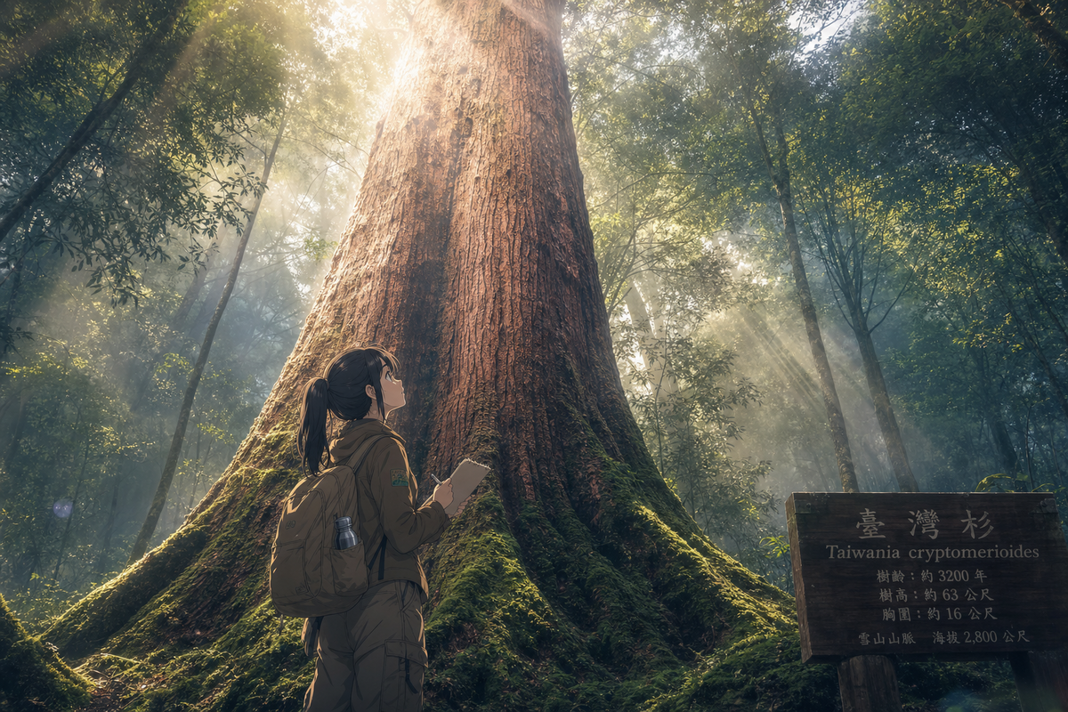
苗栗泰安鄉,大安溪流域的某一個山坡上,有一棵樹站了不知道多少年。它不需要任何人的認可。林業試驗所、成功大學與台灣神木計畫的研究團隊,歷時10年用LiDAR(激光雷達)掃描台灣高山森林,最終在那個山坡上,量到了一個數字:84.1公尺。
這棵被命名為「大安溪天劍」的台灣杉,是目前已知東亞最高的樹。超越了原本的紀錄保持者——同在大安溪流域的「大安溪三姊妹」,約80公尺。研究成果發表在國際期刊 Frontiers in Forests and Global Change。
光子量到的,不是人眼看到的
LiDAR 的工作方式,是把雷射光束射入林冠,讓光子在樹葉、枝幹、地面之間彈跳,用回程時間計算精確的三維座標。它不需要登頂,不需要爬到樹冠旁邊丈量,光子自己穿越進去。傳統測量工具的極限——林冠太密、地形太陡——在這套系統面前不再是障礙。
大安溪流域之所以還有這片台灣杉天然林,原因直接:日治時期阿里山的伐木作業持續33年,移除了347萬立方公尺的柏木。但大安溪的地形太陡峭,伐木設備進不去,台灣杉因此倖存。不是保護的力量,是地形的偶然。
那棵84.1公尺的樹,在那個山坡上站著,等了多少年,才等到一束雷射光進來把它量清楚。
第三紀孑遺,恐龍時代的鄰居
台灣杉(Taiwania cryptomerioides)是第三紀孑遺植物,與巨杉、水杉並列,在恐龍存在的年代就已出現在地球上。冰河期來了,它曾廣布北半球的族群急劇萎縮,最後只剩台灣與中國西南的一小塊地方還有天然族群。大安溪流域是台灣已知面積最大的台灣杉天然林。
台灣高海拔雲霧帶,海拔1800到2500公尺之間,年降雨3000到5000毫米。那個環境潮濕、涼爽、終年有霧,對台灣杉來說是理想生長條件。一棵站在那裡幾百年甚至更久的樹,在這套條件下,慢慢長到了84.1公尺。
台灣杉是地球上唯一學名裡帶著「Taiwania」的物種——不是為了紀念,是因為地球上只有這裡還有它的天然林。這個事實,大多數台灣人不知道。
台灣森林覆蓋率是全球平均值兩倍,卻活在自己的遮蔽裡
台灣的森林覆蓋率是60.92%,全球平均是30.3%。換句話說,台灣超過一半的土地長著樹,密度是全球平均的兩倍。這個數字本身就說明了什麼:這座島的生態資本,大到和它在國際上被看見的程度完全不成比例。
台大圖書館曾展出台灣最高樹木的全尺寸照片,策展人公開表達希望台灣巨樹被 UNESCO 認可為自然世界遺產——儘管台灣不是聯合國成員,這個方向幾乎確定遇到障礙。但這個展覽說明了一件事:有一群人已經在想,怎麼讓這些樹走出大安溪那個山坡,被更多人看見。
問題不是這些樹不夠高,是我們一直沒有對準它們的測量方式。LiDAR 給了我們一個答案:84.1公尺。這個數字是東亞之最,在國際期刊上站穩了。
它一直在那裡
我站在台灣杉樹根旁邊的時候,有一種奇怪的感覺——不是震撼,是被糾正。這棵樹不需要被「發現」,它從來沒有失蹤過。失蹤的是我們有沒有一個夠精準的工具去量它。
10年、LiDAR、三個研究單位,最後換來一個數字。84.1公尺。它是東亞最高的已知樹木,是第三紀的倖存者,是地球上唯一以「Taiwan」為名的植物屬種所長出來的一棵樹。它在苗栗泰安鄉的山坡上,不需要任何人知道它的名字,也會繼續站著。
但那束雷射光回來了,帶著數字。這次,我們知道了。
— 溫以君
延伸閱讀
East Asia’s Tallest Tree Was Always There. We Just Couldn’t Measure It
On a slope above the Daan River basin in Taian Township, Miaoli County, a tree has been standing for centuries. It didn’t need anyone to notice it. What changed in 2025 was that a team from the Taiwan Forestry Research Institute (TFRI), National Cheng Kung University, and the Taiwan Giant Tree Project aimed a LiDAR scanner at the canopy and came back with a number: 84.1 meters.
That tree, named “Daan River Heavenly Sword,” is now the tallest known tree in East Asia. It surpasses the previous record holder — the “Daan River Three Sisters,” also in the same watershed, at roughly 80 meters. The findings were published in the international journal Frontiers in Forests and Global Change.
What Light Pulses Found That Eyes Couldn’t
LiDAR works by firing laser pulses into a forest canopy and measuring the time it takes for them to bounce back from leaves, branches, and the ground below. It doesn’t require a climber at the crown. The photons go in themselves. Dense canopy, steep terrain — the limits that blocked traditional measurement for decades — stop mattering.
The Daan River basin still has its Taiwania forest for a simple reason: Japanese-era logging operations at Alishan ran for 33 years and removed 3.47 million cubic meters of cypress. But the terrain around Daan River was too steep for the equipment to reach. The trees survived not because they were protected, but because the geography was impassable.
That 84.1-meter tree stood on its slope through all of it. It just needed the right instrument to finally get a reading.
A Relic from Before the Ice
Taiwania cryptomerioides is a Tertiary relict species, placed in the same category as the giant sequoia and dawn redwood — trees that were already present during the age of dinosaurs. When the ice ages came, populations that had spread across the Northern Hemisphere collapsed. What remained were scattered stands in Taiwan and the southwest of China. The Daan River watershed holds what is believed to be the largest natural Taiwania forest in Taiwan.
The high-altitude cloud belt where these trees grow — roughly 1,800 to 2,500 meters — receives 3,000 to 5,000 millimeters of rain annually. Cool, humid, perpetually misted. Over hundreds of years under those conditions, a single tree reached 84.1 meters.
Taiwania is the only plant genus named after Taiwan — not as a tribute, but because Taiwan is where the natural forest still exists. Most people in Taiwan couldn’t tell you that.
A Forest That Outperforms Its Reputation
Taiwan’s forest coverage sits at 60.92%. The global average is 30.3%. More than half this island is trees, at roughly double the world average. The ecological wealth here has never matched the level of attention it receives — not internationally, and often not domestically either.
An exhibition at National Taiwan University Library once displayed full-scale photographs of Taiwan’s tallest trees. The curators expressed hope that Taiwan’s giant trees might eventually receive UNESCO World Heritage recognition, even while acknowledging that Taiwan’s status outside the United Nations makes that path difficult. The gap between asset and recognition is wide.
The problem was never that the trees weren’t tall enough. It was that no one had pointed the right instrument at them. The 10-year LiDAR project, run by three research institutions, produced a number that now sits in an SCI-indexed journal. 84.1 meters. East Asia’s tallest known tree, on record.
It Was Always There
The disorienting part of this story isn’t the height. It’s the timeline. A tree that has stood for centuries, in a forest that survived logging by accident of topography, in a cloud belt that feeds it thousands of millimeters of rain every year — and we’re assigning it a confirmed number only now.
LiDAR didn’t discover Daan River Heavenly Sword. It measured it. The distinction matters. There’s likely more on that island waiting for the same treatment: things that have always been there, recorded only after someone finally builds the instrument precise enough to look.
— 溫以君
Related Posts
https://justfly.idv.tw/s/p74A8af